The Official Joseph Oregon site featuring Eagle Cap Wilderness and Wallowa Lake Oregon
  • Home
  • About Our Area
    • About Joseph Oregon
    • See and Do Map
    • About Chief Joseph
    • Visit Wallowa Lake
    • Discovery Center
    • Foundry Tours
    • Joseph Stats
    • Joseph Airport
    • Local Weather
    • Artwalk
    • Joseph Panoramas
  • Recreation
    • See and Do Map
    • Camping
    • Wilderness
    • Hiking
      • Hiking Around Joseph
      • The East Moraine
      • Hurricane Creek Trailhead
      • Tenderfoot Trailhead
      • McCully Trailhead
    • Wallowa Lake Trailhead
      • BC Creek Falls
      • Chief Joseph Trail
      • West Fork Trail
      • East Fork Trail
      • Ice Lake Trail
    • Adventure Touring
      • Hat Point
      • Buckhorn Lookout
      • Joseph Creek - Troy
      • Hells Canyon Overlook
    • Zumwalt Prairie
    • Winter
Touring for Grand Views

Touring for Grand Views

The stunning landscape around Joseph Oregon is characterized by extremes of elevation. While most rightly associate the Joseph area with the mountains, a vast area is actually made up of canyons.

Read more …

Hells Canyon Overlook including the Upper Imnaha River

hells canyon overlook

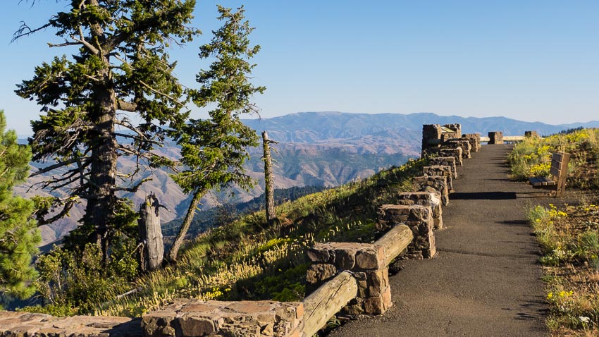
The Hells Canyon Overlook presents a perfect opportunity to travel the Hells Canyon Scenic Byway, a favorite for those into 'touring', whether by bicycle, motorcycle, car or RV. This is also a great route to see the upper Imnaha River region and some of the most beautiful old-growth Ponderosa Pine forests in the lower 48.

Explore!

Buckhorn Overlook including Zumwalt Prairie

buckhorn lookout

Buckhorn Lookout presents one of the most vast and beautiful canyon views anywhere, even if you've visited The Grand Canyon. This beautiful drive travels through Oregon’s largest natural intact grassland: The Zumwalt Prairie. In June there are wildflowers galore and the emerald green fields of grass when they’re moving in a breeze are a sight to behold.

Explore!

Joseph Creek Viewpoint including Flora & Troy

flora oregon school house

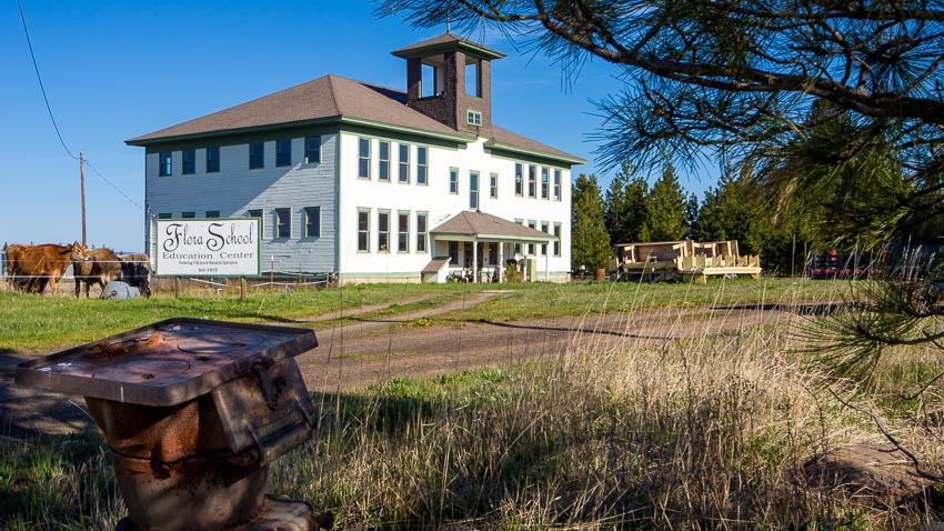
This excursion allows one to experience the many environs of the area and will also give you a look into the regions past. Joseph Canyon was a wintering ground for the Wallowa Band of the Nez Perce. The failed town of Flora was once a thriving pioneer town. Troy was settled by early Mormons in the 1890's.

Explore!

Hat Point Lookout including Imnaha & Granny View Vista

hat point bench sevel devils

This tour includes two major canyons that are distinctly unique and beautiful in their own way. Hells Canyon is the deepest gorge in North America and the Imnaha Canyon is Northeastern Oregon’s second largest; together they form the heart of the Hells Canyon National Recreation Area. Standing on the ridge across from the Seven Devils Mountains is a sight like no other, truly a natural wonder.

Explore!
sb wilderness
sb wallowa lake
sb pano
sb driving tours
sb art walk
sb airport
© 2026 Development By josephdigital
  • Home
  • About Our Area
    • About Joseph Oregon
    • See and Do Map
    • About Chief Joseph
    • Visit Wallowa Lake
    • Discovery Center
    • Foundry Tours
    • Joseph Stats
    • Joseph Airport
    • Local Weather
    • Artwalk
    • Joseph Panoramas
  • Recreation
    • See and Do Map
    • Camping
    • Wilderness
    • Hiking
      • Hiking Around Joseph
      • The East Moraine
      • Hurricane Creek Trailhead
      • Tenderfoot Trailhead
      • McCully Trailhead
    • Wallowa Lake Trailhead
      • BC Creek Falls
      • Chief Joseph Trail
      • West Fork Trail
      • East Fork Trail
      • Ice Lake Trail
    • Adventure Touring
      • Hat Point
      • Buckhorn Lookout
      • Joseph Creek - Troy
      • Hells Canyon Overlook
    • Zumwalt Prairie
    • Winter